


About the Catchment
Location | Traditional Owners | Climate | Landform | Hydrology | Geology | Soils | Vegetation | Land Use
Location
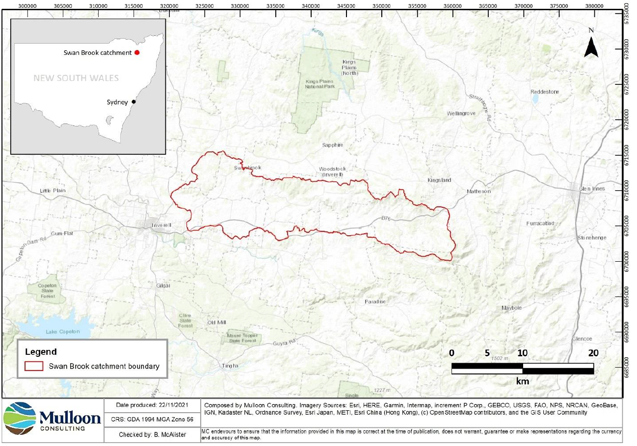
The Swan Brook catchment is located between Inverell and Glen Innes in the NSW Northern Tablelands (Figure 2) and takes in the localities of Swan Vale, Woodstock and Swanbrook. The headwaters of the catchment are on the western slopes of White Rock Mountain (20 km south-west of Glen Innes) and Swan Brook enters the Macintyre River around 5 km north of Inverell. The catchment has an area of approximately 30,000 hectares (ha).
Traditional Owners
The Swan Brook lies at or around the intersection of three Indigenous language groups: Jukumbal, Gamilaraay and Ngoorabul. The people from these groups are the Traditional Owners of the land and continue to live and practice culture in the wider region as their ancestors have done for tens of thousands of years.
Climate
The region has a warm temperate climate with warm summers and cold winters2. At Inverell, the average daily maximum temperature is 30.1°C over the summer months and 17.4°C in winter.
Rainfall is summer-dominant with an annual average of 773 mm at Inverell over the last 25 years. There are occasional snow falls in the upper parts of the catchment.
Landform
The Swan Brook has a long, narrow catchment (around 40 km long and averaging 7 km wide) which ranges in elevation from 1260 m on the slopes of White Rock Mountain to 580 m where it meets the Macintyre River. It is characterised by a central valley running from east to west with higher, steeper slopes in the headwaters, which abut the edge of the New England plateau, and lower, more undulating slopes towards the lower reaches, where it meets the wider valley of the Macintyre River (Figure 3).
The catchment is comprised of four main landscape units:
low-relief plateau – represented in the upper part of the Apple Tree Gully sub-catchment
steep escarpment – associated mainly with the edge of the high plateau and hills along the eastern and northern catchment boundary
rounded hills – dominate in the southern and western parts of the catchment
lowland plain – occurs along the lowest reaches of Swan Brook near its confluence with the Macintyre River.
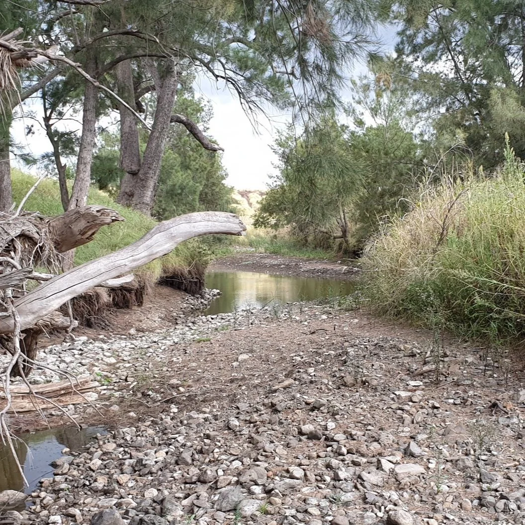
Hydrology
The Swan Brook catchment has a narrow dendritic drainage pattern, which refers to its long, narrow shape and the short length of tributaries entering the main valley (Figure 5). This shape results in water from multiple tributaries arriving in the main creek at a similar time during or after a rainfall event, causing a rapid increase in the volume and velocity of water.
Swan Brook is a 5th order stream where it meets the Macintyre River, beginning as a 1st order stream on the slopes of White Rock Mountain. One 4th order stream – Apple Tree Gully, seventeen 3rd order streams (notably Zig zag, Chinaman’s, Main, Long, Schumacher’s and Boiling down gullies and Ibis Glen, Wet and Young’s creeks) and more than 90 1st and 2nd order streams flow into Swan Brook (Figure 5).
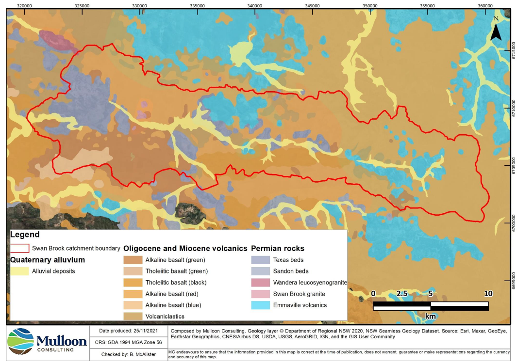
Geology
The dominant surface geology includes several types of basalts and volcaniclastics belonging to the Central Province volcanics geological unit, and some unconsolidated alluvium belonging to the Alluvial valley deposits unit along parts of the main valley6 (Figure 6). The volcanic rocks date to the Oligocene and Miocene geological epochs and are between 33.9 and 5.33 million years old. The alluvial deposits are from the Quaternary period and formed during the last 2.58 million years.
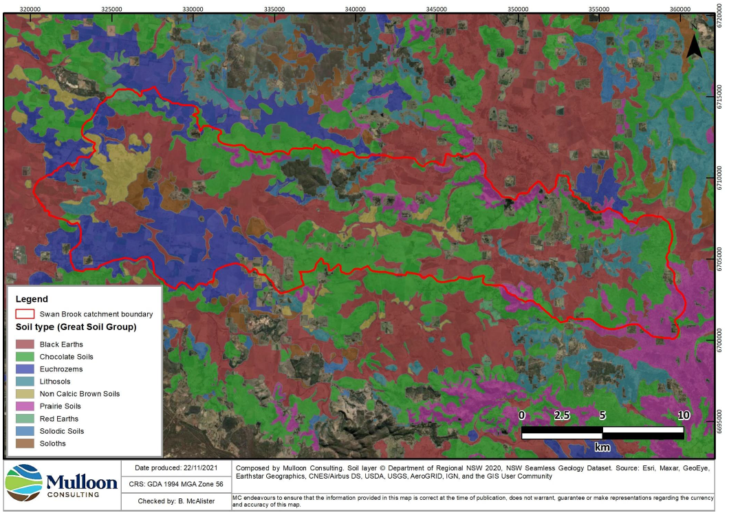
Soils
The soils in Swan Brook catchment (Figure 7) are primarily derived from the different types of basalt rocks and there are three main soil types in the valley:
• Black earths (Vertosols) are the most common soil in the lowest parts of the main valley and have very high clay content and inherent fertility. These soils contain clays with shrink-swell properties that cause them to develop deep cracks when they dry out.
• Chocolate soils (Dermosols) occur on slopes, are brown, well-aggregated and have high fertility.
• Euchrozems (Ferrosols) are more highly weathered red basalt soils with lower inherent fertility than the black and brown basaltic soils and primarily occur on the low hills in the western part of the catchment.
Some other soil types in the catchment that are less abundant include:
Non-calcic brown soils (Chromosols) that occur on parts of the main valley floor.
Prairie soils (Dermosols) that occur on some steeper slopes in upper parts of the catchment.
Lithosols (Rudosols) that occur on steeper, rockier slopes.
Soloths (acidic, texture-contrast soils; Kurosols) that occur in localised patches in the lower reaches of the catchment.
Vegetation
The catchment is comprised of approximately 60% non-native and 40% native vegetation. There are 17 native plant community types and these are distributed based on geology and soil type, the localised climate, and land use history. These 17 communities each belong to broader classes of vegetation and can be classified into the following groups:
Grassy woodlands: occur on the higher-fertility soils and so have been largely replaced with pastures and crop production
Riverine forest: occur in patches along Swan Brook and some larger tributaries
Native grasslands: occur in areas that have not been cultivated or pasture-improved. Most native grasslands are likely to have been derived by historical clearing of native forests
Dry sclerophyll forest with a shrubby or grassy understorey: mostly occurs on steeper, rockier parts of the catchment with less favourable agricultural soils.
Heathlands occur in a few small, localised patches in the eastern part of the catchment.
Native woodlands and forests cover around 29% of the catchment and native grasslands cover 11%. Non-native vegetation is made up mainly of introduced pastures and cropped areas.
Land Use
Swan Brook
Current Land Use
The catchment is currently used primarily for mixed farming with sheep and cattle grazing and fodder crop production as well as some larger cropping enterprises. Conservation management of some land in conjunction with primary production has taken the form of replanting woodland trees, erosion repair and carefully planned grazing in riparian areas and woodland remnants.